congestion

If I were in the habit of taking photos, I’d have kept the digital camera I’m borrowing for a while in the front of the car with me on my drive back up here instead of carefully wrapping it in a warm hat for padding and putting it in my luggage. That way I’d have been able to take a picture of the traffic signal perched high up on the edge of a cliff along US 101 somewhere on the northern California coast where a slide and the resulting road construction has forced the highway down to only one lane for a few hundred feet. I was the third car in line and had to wait about five minutes while the oncoming traffic – I saw only a single car go by – passed and then the light turned green. That would have been more than enough time to get a few shots of the non-intersection.

On the other hand, not having the camera near me might have saved me some time. Most of 101 up to Florence, where I turned inland to meet I-5 north of Eugene, is quite beautiful and I easily could have found myself stopping each time the road dropped down from the headlands and hit sea level. As it was, I drove for about 14 hours on Sunday, after 11 on Saturday. I can confirm, however, that it is possible to drive all the way from southern California to Vancouver with only one overnight stay along the way – and still avoid the mountains and their unpredictable weather near the California-Oregon border. Possible, but very tiring. I got to Eugene at about 3, Portland at about 5, Seattle about 8, the border 10, and my apartment just before 11 last night. I started driving at 8:30.

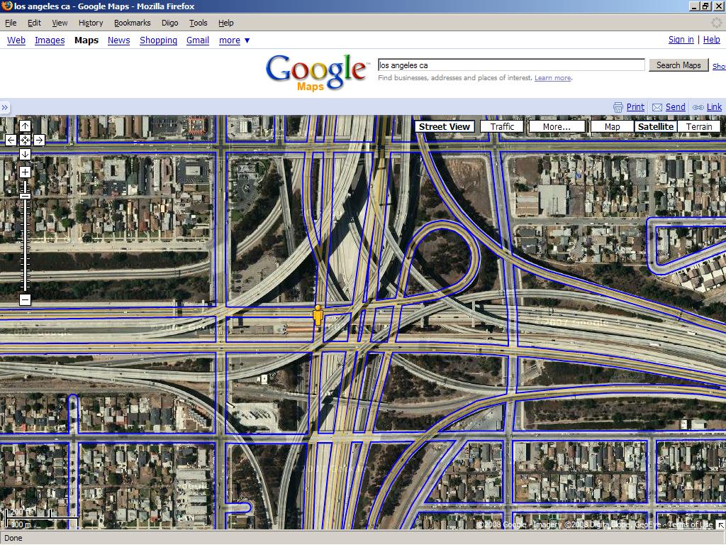
freeway density

Don't worry about the street view pedestrian - there's a light rail station down there

I’m going to be in the Los Angeles area (technically I’m not staying in LA itself) for the weekend. I don’t really have any plans. I might drive over to take the light rail somewhere.

(link to labeled map)

driving behavior

I don’t know how much you can tell about a city’s drivers by walking around. Probably not much. I remember walking in San Francisco in 2000 and being very conscious of the fact that I had seen reports on the local news saying that the city had a poor pedestrian safety record. But of course I was a pedestrian.

Last year I spent a few months in Washington, D.C. and as a pedestrian I felt fine. But the driving behavior I saw at a few places – including two intersections in particular near the Takoma Metro station that I walked by every day on my way to and from the place I was staying – looked pretty dangerous. People would race down two lane streets to try to be the first to reach the spot where the street collapsed into a single lane; people would pass on one-lane streets by pretending to wait to turn right and then slamming down on the gas to go forward as soon as the light changed; people would cut off oncoming traffic to turn left when lights changed; and in general people did not leave much time to make turns. Had these been a few isolated incidents here and there, I wouldn’t have thought much about it, but I regularly found myself thinking “that was insane!” after witnessing something crazy from the sidewalk. But I never saw an accident.

Recently I saw a story in the Examiner (via somewhere I don’t remember): “D.C. drivers most accident-prone in nation, insurance study finds”:

D.C. drivers are more likely to be in auto accidents than drivers in any other city in the country, and Alexandria and Arlington drivers follow closely behind, according to a new study.

D.C. drivers average one accident every 5.4 years, making them almost three times more collision-prone that drivers in Sioux Falls, S.D., which ranked as the safest driving city in the 2008 Allstate America’s Best Drivers report.

The number means D.C. drivers are 84 percent more likely to be in an accident than the average driver nationally and places the city as the most dangerous for drivers among the 193 studied.

The rankings can be found here (under 2008 data). Note that San Francisco also does poorly in the rankings at 185, but there’s a huge gap between D.C. and almost all of the other listed cities in terms of “Relative Collision Likelihood” (compared to the national average): D.C. comes in at nearly 84% more likely and S.F. at just over 44% more likely. I haven’t looked into the methodology, but the Examiner says that the numbers are based on claims filed in 2006 – so that’s before I went to D.C.

That Examiner article also provides some information about congestion:

The Washington area ranks as the second-most-congested in the country, tying with Atlanta and San Francisco and trailing only Los Angeles.

The interesting thing there is that the Washington area, Atlanta, and San Francisco (assuming this means the San Francisco area) are the three regions that built similar heavy-rail transit lines after the second world war. I suppose a transit skeptic would take this as evidence that the rail lines haven’t done their job, but the fact that Los Angeles, which did not build any lines back then ranks lower, suggests that the costs of not building transit could have been higher. It also suggests that the transit projects facilitated growth (and at least in the case of BART, that was one of the goals).

beaten tracks

Talk of how we’ve entered a new “gilded age” tends to center on questions of inequality, but it has also led a number of people to draw analogies (sometimes well, sometimes poorly) between the old Gilded Age and our time. I remember during the internet boom of the late 90s hearing people say that the internet – or the information superhighway, as they said back then – was a lot like the 19th century railroad: annihilation of time and space, generation of great fortunes, boom and bust, and so on. But lately it’s been looking like the 19th century railroad might be more like the 21st century railroad.

There’s political influence and looming battles over regulation:

Two western railroad companies are donating an unusually high amount — more than $1 million — to the Denver National Convention (DNC) host committee — at the same time that railroad regulation proponents say they’re close, for the first time in decades, to winning additional oversight of the rail industry.

The companies offering up their political support include Union Pacific (UP) and Burlington Northern Santa Fe’s (BNSF). Nebraska-based UP disclosed its $1 million donation to Democratic convention organizers; company officials have said that an additional donation has been made to the Republican National Convention, which will be held in Minneapolis-St. Paul, though they haven’t revealed that amount.

And there are likely to be fights over rates ahead:

Meanwhile, the railroad industry’s long-standing antitrust exemption has attracted the attention of lawmakers. They seek to eliminate the exemption and closely examine the rates railroads charge to haul freight, which the industry says would cripple its expansion at a critical time.

The railroads’ rate structure has also drawn the ire of some of their customers: Nearly 30 antitrust lawsuits have been filed against major railroads in recent months, including one by agri-giant Archer Daniels Midland last month, alleging collusion and price-fixing.

For some lawmakers and advocacy groups, today’s rail industry recalls that of the late 1800s, when the only ceiling on rates was the limit of a rail baron’s avarice. The railroads say today’s rates are reasonable and reflect something the industry has not had in decades: pricing power.

Meanwhile, what’s the Gilded Age internet? The telephone. Seriously, that’s a very well-drawn analogy, from the story of the replacement of “the people’s telephone” (or “telephone 2.0”) with “telephone 1.0”, to the sobering concluding speculation. I couldn’t help but think of net neutrality while reading it.

multilateral discarmament

Growing up near and then in Berkeley, I got used to the traffic barriers and speed bumps that dot the residential side streets not far from downtown and the university campus. I’ve heard people unfamiliar with the area complain about the inconvenience they cause drivers trying to get across town, but my parents knew where to turn to avoid getting dead-ended. That was sort of the point: keeping passers-through on the major streets and non-local traffic off the smaller ones.*

Today I see that some of the counties outside DC have been adopting similar tactics for similar reasons. The Post report makes it sound like a war:

Scores of commuters were using Southampton Drive in Kings Park every day to cut between Rolling and Braddock roads and avoid several stoplights and bumper-to-bumper congestion. The community petitioned for and added speed humps every block or so. The humps were followed by four-way stop signs, a 15-mph speed limit and concrete “bump-outs” that make the road seem narrower and cut speeds.

Drivers stopped using Southampton but switched to parallel Eastbourne Drive. The community took the unusual step of installing a concrete barrier to prevent a right turn onto Eastbourne. A “Do Not Enter” sign made it even more daunting.

So drivers took a left off Southampton and used Kings Park Drive. The community responded with more speed humps and speed restrictions. Then it brought out the heavy artillery: traffic circles.

I believe that’s in Fairfax county. Here’s Montgomery County:

Chevy Chase and Bethesda have learned to combat cut-through artists by making it nearly impossible to get from Massachusetts Avenue to Wisconsin or Connecticut avenues via neighborhoods. Once-tempting streets now have an array of signs with so many prohibitions that drivers sometimes have to pull over to figure out whether and when to turn.

Signs at Bradley Boulevard and Kennedy Drive (an alluring alternative to the parallel, choked Little Falls Parkway) prohibit left or right turns during rush times. And trucks and buses weighing more than three-quarters of a ton can’t drive through. However, the signs specifically allow emergency vehicles on Kennedy Drive’s precious pavement.

Nancy Floreen, a Montgomery County Council member, said the county “wins the world prize on the footnotes we have on our street signs, like ‘No right turn when the moon is full’ sort of thing.”

There have been real benefits –

Sharon S. Bulova, the Fairfax County supervisor who represents Kings Park, said the neighborhood’s efforts reduced cut-through traffic by 60 percent.

“It really saved the community,” Bulova (D-Braddock) said. “They used to have cars ending up on lawns trying to take a curve too fast. Parents were fearful for kids and pets. People were in a hurry and in commuter mode.”

– but escalation is not without its costs:

Still, in some neighborhoods, even residents complain about living around so many restrictions, Floreen said.

Tracey Hughes of Somerset lives just off Dorset Avenue, which has the full complement of traffic humps, rumble strips, stop signs, crosswalk signs, electronic speed monitors and four-way stop signs at every block.

Hughes, who has lived in the neighborhood for six years, said the street doesn’t appear to have too much traffic. But, she said, she assumes town leaders know what they are doing by installing the driving disincentives.

These battles might not stop unless something changes the terrain:

Transportation officials say residents want it both ways. Everyone wants roads that are quick and congestion-free as long as those roads don’t run in front of their homes. Instead of citylike street grids that distribute traffic evenly, suburban developments in recent decades have emphasized cul-de-sacs and winding streets that go nowhere and lacked through streets that could be used by outsiders.

That, said Ronald F. Kirby, transportation director of the Washington Council of Governments, forces almost all traffic onto arterial roads, which are barely able to handle it, especially during rush periods.

Bogged-down traffic on arteries pushes more traffic onto interstates, which were not designed for local trips. For example, Kirby said many motorists who use the Capital Beltway travel only an exit or two, an indication that regional arteries aren’t doing their jobs.

If only there were some kind of weapon that could take pressure off the through roads, some way of taking masses of people and transporting them from place to place, some tool that could be used to transform land use patterns…

*I usually walked to school on an almost straight line, right past the barricades. When my parents drove they took the side streets. When I took the bus I walked up or down the block to one of the main streets.
sketchy subways

Article. Illustrations. (U-bahns, too.)

I liked this:

Frost also rides the F train and is buddies with Velandria on Flickr’s subway sketchers group. But the two have never met face to face.

Meanwhile, the New York Times tried to draw a quick portrait of riders on the Q train one morning. Kind of disappointing, although I guess they didn’t have much time. (Incidentally, both articles came out around the July 4th weekend, probably because those were expected to be slow news days.)

the west “coast”

The geographical problems with this paragraph leave me nearly speechless:

Do you really need to ask? Obviously, I’m for building high speed rail. The California coast is a potentially excellent rail corridor with a whole bunch of kinda close urban areas. I’d say that there (potentially extending upcoast to Portland, Seattle, and Vancouver) is one of the most promising possible areas for rail improvement. It’s an expensive undertaking, but one that will pay large dividends for a long time once it’s done.

(I am, of course, for high-speed rail, but I am also in favor of knowing something about the layout of the Pacific coast and its transportation routes.)

one for on the road

Yglesias:

I’m not sure a drunken commute is really the ideal we need to be aspiring toward.

I don’t know about that. It may be more dangerous to outlaw alcohol on transit than to allow it.

transfers

I’ve been meaning to start writing about transportation stuff ever since this post, but other things have gotten in the way. Here are some links I’ve collected in the last month:

Over at The Bellows, Ryan Avent asks his commenters, and they answer:

Why isn’t transit a bigger part of the national discussion on energy/climate change/congestion/etc.?

Later, his commenters ask him:

What are the obstacles to high speed rail in this country?

To his answer of “primarily…demand and money” I would also add state and local politics. Some routes might seem obvious when you think of them in terms of endpoints, but the ground-level details are a lot more complicated. I didn’t follow it that closely, but I remember there being a heated debate over the Bay Area end of the San Francisco to Los Angeles route: should it start in SF or Oakland? what pass should it use to enter the Central Valley? and so on. Even now when the line seems to have been settled in San Francisco’s favor, there’s a conflict with the Union Pacific company over use of right-of-ways. (If you’re interested in the California project, check out the California High Speed Rail Blog, which has much more detailed coverage of this.)

Another thing to keep in mind is that high-speed rail necessarily bypasses a lot more towns than regular rail – too many stops and it’s just a rail line with a high top speed. There’s only so much time you can save over regular rail on a Washington, DC to New York route if you also stop in Baltimore and Philadelphia and other places, but it’s hard to see those cities agreeing to be skipped over (and it’s not clear that they should). And indeed, as Avent and some of his commenters point out in the linked threads, in a number of places around the country it makes more sense to upgrade existing service rather than to build “true” high speed rail.

As a sidenote, apparently some of the high speed routes in Germany have been criticized for having so many stops that the average speeds aren’t really that great. By contrast, the couple of times I took the TGV south from Paris, the first stop didn’t come for about 3 hours – longer than the entire Acela trip between New York and DC. My anecdata is a few years old, though, so I don’t know what the European systems are like now. Aside from being better than ours.

    And speaking of Europe, Paul Krugman points out that Europe moves proportionally less freight by rail than the United States does. I have anecdata for this too: I was surprised at how few freights I saw as a passenger in Europe a few years ago as compared to what it’s like to ride Amtrak. The only place I remember with a significant freight presence was the northern end of the line between Stockholm and Kiruna, Norway, where trains carry ore from a Swedish mine to the coast. The combination of gorgeous scenery (fjords and mountains) and natural resource extraction industry (mining, the freights, and the transshipment facility in Kiruna) made the area feel almost (American) western to me.

    Leaving rail aside for the moment, Matthew Yglesias considers Bus Rapid Transit (BRT) and worries: “What I primarily fear about BRT is that we’ll get into a “defining BRT down” scenario since it lacks a very clear definition.” In Berkeley, some BRT opponents appear to be trying to do just that.

    Finally, in the early 1980s John Stilgoe wrote a book, Metropolitan Corridor, examining the geographical changes the adoption and expansion of the railroad brought about in the United States. I remember reading a review – I haven’t read the book, but I looked up the reviews when I was in grad school for research-related reasons – which, though generally positive, criticized the book for being perhaps too nostalgic towards the railroads, given their postwar decline. That was then; Stilgoe has now written a new book on railroads, and from the looks of it, there’s no need for nostalgia.